Rupert Parker is hiking around the Essex coast from Tollesbury to the Thames in honour of The Essex Serpent TV series.
Essex is something of a hiker’s paradise if you know where to go. A new Apple TV+ series, The Essex Serpent, based on the novel of the same name, highlights the stark beauty of the county’s coastline. Of course, there are the obligatory caravan parks, but they’re mainly clustered around the towns and what lies between is wild and unspoilt. Indeed, one section skirts one of the most isolated spots in England so follow me as I go hiking around the Essex Coast
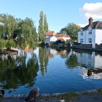
I take the Colchester train from Liverpool Street and get off at Witham. From here it’s a taxi to Tollesbury Marina, my starting point for hiking around the Essex Coast. The tide’s out, the boats are resting on the mud and there’s nobody around. I set out to follow the Saltmarsh Coast Trail on the seawall around Tollesbury Wick, an area designated as a nature reserve, with Mersea Island opposite. In the distance is Bradwell Nuclear Power Station, somewhere I’ll pass tomorrow.


The bird life is abundant, with lots of waders, and the only people I see are a couple collecting shellfish in the shallows. There’s nothing else for another three hours before I reach the caravan parks, just outside Maldon. Suddenly there are dog walkers, pubs with drinkers outside, but it’s still a long way around numerous inlets before I reach Maldon. My accommodation is at the top of the only hill for miles, and I’m relieved to discard my boots and soak my feet in a hot bath.
After yesterday’s interminable inlets, rather than face more of the same, I decide to cheat and take the bus. It drops me off at St Lawrence, another caravan haven, and I set off along the seawall. It’s sunny with a gently breeze, and there are many sea birds feeding in the water. I soon arrive at Bradwell Marina, chock full of boats and there’s even a pub, but I don’t linger.

The nuclear power station looms ahead, long decommissioned. although there are plans to restart. I can see the village of West Mersea, close across the channel, and nearer, at water’s edge, are sunken barges, improvised sea defences. Ruined pill boxes are dotted along the shore, once a protection against German invasion. I pass long shell beaches with the occasional seated fishermen. Soon I’ve turned the corner and arrive at the Othona community where I’ll be spending the night.
Next morning, I take a quick look at the chapel of St Peter on the Wall, one of the oldest intact churches in England, dating from the 7th century. The sun is out but the dew is heavy on the sea wall, and soon my boots are soaked. There are more beached barges and I’m walking through one of the bleakest spots in the UK – nobody lives here, and I see no people. The skies here are huge.


After facing the open sea for a handful of miles, I reach the Crouch estuary and turn upriver. During WW2 this was thought a potential invasion route and the seawall is lined with pillboxes including a massive fortification just slightly inland. In the middle of the estuary is Foulness, the fourth-largest island in the UK. It’s still used as a firing range by the military and loud bangs disturb the silence. As I near Burnham on Crouch, the yachts are out in force in the channel. It’s a delightful place, so I stop for an ice cream on the sea front.
Next day I decide to take it easy and just walk upriver to the pub in North Fambridge. I leave Burnham’s Yacht Marina, still following the sea wall, past the tiny hamlet of Creeksea. There’s nothing much else until the sea wall suddenly disappears and I’m directed inland and start to climb. Locals know this as ‘The Cliff’ and suddenly the landscape opens up in front of me.


It’s only a minor undulation and I’m soon back on the flat on the sea wall. I pass the marina at Althorne before reaching the excellent Ferry Boat Inn at North Fambridge. The ferry is long gone but they’re still providing excellent beer and food. It’s so good that I linger too long and end up taking the train back to Burnham.
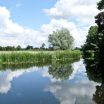
I resume the trail by phoning the ferry, just a one-man small inflatable, to take me across the Crouch to Wallasea Island. Over 3 million tons of earth from the Crossrail excavations were dumped here to create a wildlife habitat under the protection of the RSPB. Arable farmland has been converted to saltmarsh, mudflats, lagoons and grazing marsh but I’ve no time to linger.
I head inland through the Paglesham hamlets of Churchend and Eastend, across huge fields of grain, to end up once again on the seawall by my third river. This is the Roach and I follow its banks to the crossing place at Rochford. I’m now on the outskirts of Southend and, rather than tramp through urban streets, I take the bus to centre. It’s then a pleasant walk along the prom, past the famous pier, to my B&B in Thorpe Bay.

Rather than trudge through the centre of Southend, I take the bus to Leigh on Sea. This is the start of the Thames Estuary path which will take me all the way to Tilbury. It mostly runs parallel to the railway line, with stations dotted throughout, so it’s easy to do day walks, just tackling short sections.
I follow Hadleigh Ray riverbank, with Hadleigh Castle above me and Two Tree Island to my left, to South Benfleet and then inland to Pitsea. I turn cross country, past Vange Marsh, then through Fobbing Marsh Nature Reserve. I get my first view of the Thames at Stanford Warren nature reserve, flooded gravel pits with reed beds full of birds. From here it’s a short walk to Stanford Le Hope.
Next morning, I follow the railway line before entering Thurrock Thameside Nature Park. Once a landfill site, it’s been reclaimed by nature and contains a huge lake, excellent for bird watching. At East Tilbury, I finally reach the Thames, with the impressive 19th century Coalhouse Fort, guarding the river. Originally built to protect London from the French, it was repurposed in WW2.


The seawall follows the curve of the river to the 17th century Tilbury Fort now fully restored. Henry VIII built the first defences here and Queen Elizabeth famously rallied her army nearby to face the threat of the Armada. These days the Armada has been replaced by massive cruise ships which dock nearby, next to the Gravesend ferry.
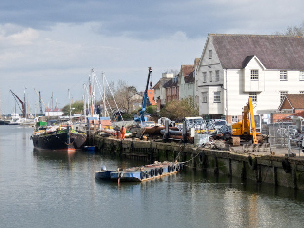
I press onwards to Grays, not the most inspiring place, but I’m soon back at the Thames, stopping for fish and chips at a riverside pub. Huge oil tankers and container ships ply this stretch of the river, and the sea wall has been transformed into a gallery of graffiti. Passing underneath the Dartford Crossing Bridge, I arrive at Purfleet, my final destination of my hiking around the Essex Coast

It’s time for a celebration drink – I’ve walked around 100 miles in seven days, crossed three rivers, the Blackwater, the Crouch and the Roach, before arriving on the banks of the Thames. I feel some sense of achievement and, of course, I could continue right into central London – but that’s something for next time.
Tell Me More About Hiking Around The Essex Coast
Greater Anglia has direct trains from Liverpool Street to Witham.
Visit Essex has information about hiking around the Essex Coast and the county.
The Saltmarsh Coast has information about hiking around the Essex Coast.
Explore the Thames Estuary Path has maps and a detailed guide.
Luigi’s Al Fresco is a comfortable place to stay in Maldon and has good Italian cuisine.
The Othona Community, near Bradwell, provides a good welcome.
The Thatched Cottages in Burnham on Crouch are a couple of atmospheric, immaculate restored, historic dwellings.
The Ferry Boat Inn in North Fambridge has rooms and excellent food.
Suenos Guesthouse in Southend has sea views and 5* accommodation.