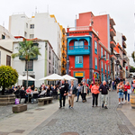
The most westerly and smallest of the Canary Islands, El Hierro was once considered the end of the world until Columbus discovered America. It’s still pretty remote and there’s no easy way to get here from the UK. Although it does have an airport, you have to change planes in Tenerife, La Palma or Gran Canaria, or brave the ferry from Tenerife. Of course, the advantage is that it caters for the more intrepid traveller and there are no high rise hotels or sprawling resorts here.
The diversity of its natural landscapes with huge areas of woodland, endemic plant species and crystal clear waters has led to it being classified as a UNESCO Biosphere Reserve and Geopark. This means that it’s likely to stay unchanged for the foreseeable future and will never see the sort of development that has transformed Tenerife.
The island is less than 50 km long and has the highest volcano density in the Canaries, with over 500 extinct craters, and another 300 covered with more recent lava flows. The last eruption was in 1793, although there was one under the sea as recently as 2014, there’s nothing to worry about. The main settlements are in the mountains, rather than by the coast.
Valverde, the capital, sits in the north and is often shrouded in mist. A volcanic spine runs down the centre with the highest point, Malpaso reaching 1501m. On one side steep cliffs tumble down to the sea, while on the other are the fertile flatlands of El Golfo, with vineyards and plantations. The south and west are the volcanic Badlands with spectacular black lava flows contrasting with white flecked waves, whipped up by the strong winds.
There’s a good road running around the island and narrow twisting switchbacks take you over the top. Fortunately, there’s little traffic, but you do need to keep your nerve, especially as you’re often in mist. In the far south, near the port of La Restinga, is Cala de Tacoron, a beautiful swimming spot with a simple café.
The best way of exploring is on foot, although a car is essential if you’re going to reach the more remote parts. That means circular walks are the order of the day which is a pity as the GR131 runs the length of the island and has spectacular views. However, it’s possible to do this in sections and there’s an efficient local bus service.
I start with an easy circuit which follows the coast in El Golfo.
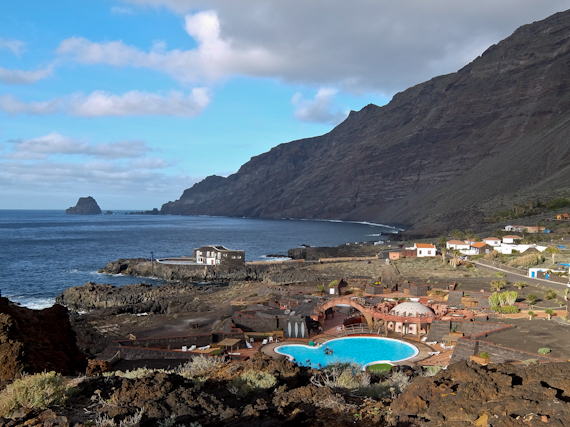
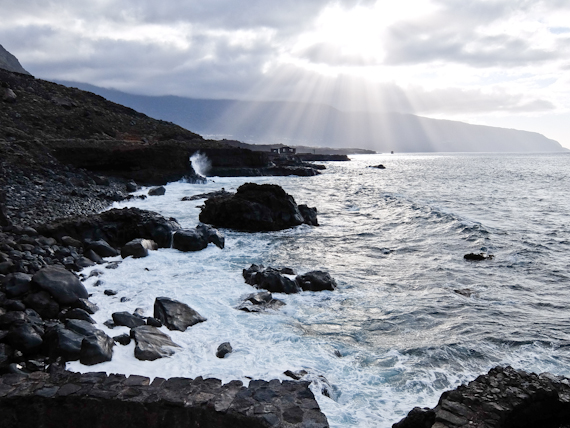
Punta Grande has a tiny hotel with just four rooms and once was listed as the smallest in the world in the Guinness Book of Records. The trail from here has been boarded so it’s easy underfoot and it offers stunning views of the crashing surf, crossing lava flows, to reach La Maceta. This is no more than a car park and a café, although there are rocky pools where it’s possible to swim.
The path then turns inland, past plastic banana greenhouses, to reach the Ecomuseo de Guinea. Inside there are depictions of early life on the island and a project to conserve the native giant lizards of El Hierro. They grow up to 60cm long and were almost extinct but now are being reintroduced from this breeding centre. From here, a quiet road leads back overland to Las Puntas.
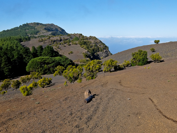
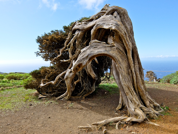
Next day I drive to the unpopulated western end of the island for the La Dehesa Circuit. It begins at the Ermita de Los Reyes, where the statue of the virgin is taken out every four years and carried the length of the island. I follow a dirt road upwards, through pine trees, then an avenue of cypresses and follow a sign to El Sabinal. Here are ancient juniper trees, bent double by the wind.
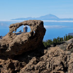
Now I follow the coast to reach Mirador de Bascas, with spectacular views of Sabinosa and El Golfo, to the east. From here, the path climbs quite steeply upwards on a walled track laid out with steps. I can see the village of Sabinosa below but cross fields, through more juniper, and finally, arrive back at Ermita de Los Reyes.
I leave the most strenuous walk to the last, knowing I’m going to need all my energy.
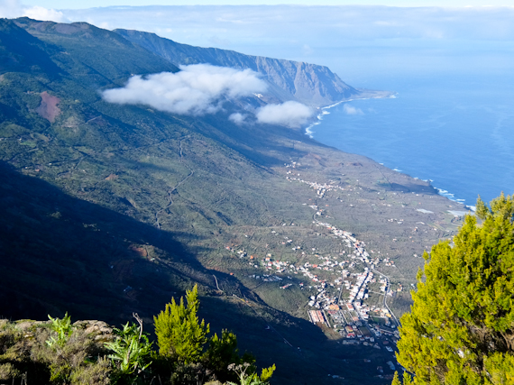
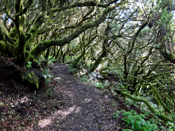
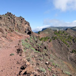
From Tigaday in El Frontera, the path climbs steeply past fields of vines and old wine presses. El Golfo is laid out below me and I enter a dense patch of laurel forest or laurisilva. Still climbing, suddenly I’m out in the open, trudging over black ash to reach the crest of El Hierro at 1350m.
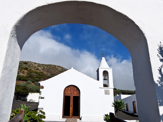
I now follow the GR131 northeast, a level trail along the volcanic spine of the island, to the village of San Andres. The mist has descended and there’s nothing to see when I reach the Mirador de Jinima. Still, as I zig-zag down on one of the oldest tracks on the island, I’m soon into the sunshine. I pass Candelaria with its distinctive church bell tower perched on an ash cone, and arrive back in El Frontera.
There’s something special about El Hierro which marks it out from the other Canary Islands and it’s not just nature. Restaurants are good value, use locally grown produce, with lots of fish, and there’s even decent wine. But be careful. English is not widely spoken so you’ll need to brush up on basic Spanish and the few beaches only have black sand. And there’s always wind and maybe some mist, but the play of light is magnificent – it’s my kind of island.
Tell Me More About El Hierro
Spain Info has information about the country.
El Hierro Travel has information about the island.
Ryanair flies to Gran Canaria and Tenerife South from London Stansted.
The Stansted Express is the quickest way to the airport from central London.
Binter flies to El Hierro from Gran Canaria and Tenerife North.
Apartamentos Los Verodes are self-catering apartments in Frontera.
Walking on La Gomera and El Hierro by Cicerone is an indispensable guidebook.
If you enjoyed this review, why not check out these similar posts:
 Guide to walking La Palma. Discover dream landscapes in the Canary Islands
 On Foot in Gran Canaria, Discover the rugged heart of the wonderful Canary Islands
 Walking La Palma. The Canary Islands beautiful isle has never looked better.
 Best Hiking around La Gomera. Discover a wonderful island for hiking and trekking.